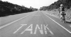
Surf, sand, and picturesque bluffs. Salty breezes and the ever-present licorice scent of wild fennel. The rhythmic bumping of your bike tires over the pavement of an old four-lane highway, abandoned save for the occasional lizard or snake that may cross your path. This and more (perhaps tanks rumbling and helicopters chopping on practice maneuvers) awaits you on the designated cyclist’s route to Orange County through Camp Pendleton. The route may on occasion be closed due to extensive military maneuvers. These closures tend to be publicized in the local media, however.
The Oceanside-to–San Clemente route, some 20 miles one-way, takes you along a combination of access roads within the base, long-abandoned sections of the old US Highway 101, and narrow bike paths. If you get an early start, you’ll often receive a welcome assist from the prevailing west or northwest wind on the return leg of the trip back to Oceanside. This breeze usually starts up around mid-morning and tends to intensify by early afternoon.
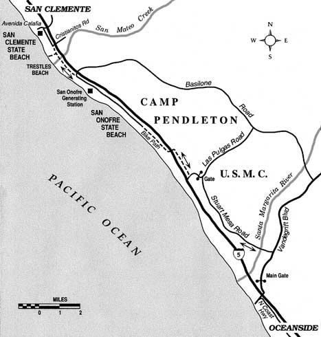
Places to park your car can be found in residential or commercial areas on either side of Interstate 5 at the Harbor Drive/Vandegrift Boulevard exit in north Oceanside. Start pedaling north on Vandegrift, and you will soon reach Pendleton’s main gate. In order to proceed, you must show identification and you must be wearing a helmet.
Beyond the gate, continue on Vandegrift Boulevard for 1.5 miles and then make a left turn at the traffic light, Stuart Mesa Road. Heading north, you cross the Santa Margarita River and climb a half-mile-long incline to reach Stuart Mesa, where agriculture (on land leased to growers) mixes with various military facilities.
At nine miles into the ride, you turn left on Las Pulgas Road and pedal up and over a small hill toward Interstate 5. Just beyond the railroad undercrossing, but before the I-5 ramps, veer right onto a section of the old Highway 101 roadbed. After 1.5 miles you bend left, pass through a tunnel under the freeway, and pick up the old highway again, this time much closer to the brink of the coastal bluffs.
The south boundary of San Onofre State Beach is next. Ahead lies 3.5 miles of flat riding through a linear parking lot and blacktop camping areas, all fashioned out of the old highway right-of-way. On farther, past the dome-shaped containment vessels of the San Onofre Nuclear Generating Station and just before an I-5 overcrossing, make a sharp left turn onto the paved bikeway leading to San Clemente. A side path on the left leads to surfer-friendly Trestles Beach, while the main path continues uphill to an I-5 frontage road at the south boundary of the city of San Clemente. A short mile ahead, you’ll find San Clemente State Beach (a blufftop park), with an obscure pedestrian connection on the left between the frontage road and the park’s picnic and camp grounds. This is a good spot for a snack and some liquid intake; then it’s time to head back to Oceanside, using the same route.
Camp Pendleton Bike Traverse
Ride through the big Marine Corps base from Oceanside to San Clemente.
Distance from downtown San Diego: 40 miles
Biking length: 40 miles round trip
Difficulty: Moderately strenuous